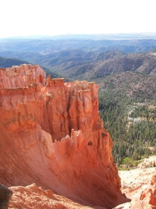
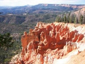
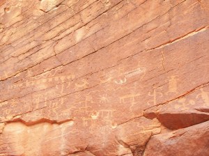
Slickhorn Canyon Ruins, UT

Slickhorn Canyon, NV

Slickhorn Canyon
offers an alternative for those who are interested in the Anasazi Ruins of Cedar Mesa but want more solitude than Grand Gulch can offer. The ruins are not as extensive as those in Grand Gulch, but Slickhorn does have one bonus: an almost perfectly preserved kiva, with the original roof still completely intact. The BLM has even provided a replica of an Anasazi ladder to give hikers access to the subterranean room through the opening in the roof. Also, the Slickhorn ruins do not appear to have been ravaged by Richard Wetherill and the other pot hunters of the late 1800s who excavated so many of the Grand Gulch ruins. Perhaps they didn’t know about Slickhorn Canyon.
Like the Grand Gulch, Slickhorn Canyon runs in a southeasterly direction from the edge of Cedar Mesa to the San Juan River. There are a number of side canyons which join the main canyon from the east side, and it is through three of these side canyons, First Fork, Third Fork, and Trail Canyon, that most hikers find access to Slickhorn. The hike described here is a loop between First Fork and Trail Canyon.
Like the Grand Gulch, Slickhorn Canyon runs in a southeasterly direction from the edge of Cedar Mesa to the San Juan River. There are a number of side canyons which join the main canyon from the east side, and it is through three of these side canyons, First Fork, Third Fork, and Trail Canyon, that most hikers find access to Slickhorn.
The hike described here is a loop between First Fork and Trail Canyon.
From the parking area at the top of First Fork, begin by walking down the bottom of the drainage in a southwesterly direction. There are no signs and no maintained trail, but enough hikers use this route that a primitive trail is beginning to form. After a fifteen minute walk you will come to a small pouroff that you can easily get around by detouring a short distance into a shallow side canyon on the left. Another mile down canyon will bring you to a much larger pouroff that cannot be dealt with so easily.
This time you will have to climb up the south side of the canyon to a bench just below the top of the mesa that you can follow around the obstacle. Many hikers before you have taken this route, so look for the cairns they have left behind to guide you.
While you are on the bench be sure to look into the back of the short side canyon on the opposite side of First Fork, and you will see a small ruin near the top of the canyon wall. Also, take note of a large sandstone monolith that stands near the opposite side of the main canyon, about 500 yards downstream from the pour off. This monolith is approximately opposite the point where the trail again descends to the canyon floor, so be sure to watch for cairns.
The monolith will also help you find your second ruin. Look carefully at the opposite canyon wall about 200 yards downstream from the monolith and you will see a large alcove about half way up the side of the canyon wall. The ruin is in the back of this alcove. Once you reach the canyon floor, walk downstream for five or ten minutes until you see a faint trail leading up to the right. This is the way to the alcove. The ruin is not visible from the bottom, and there are very few cairns marking the assent (perhaps removed by rangers?), so it is easy to miss.
Some scrambling is necessary, but the climb is not difficult. You will certainly want to spend some time checking out this ruin because it contains an extraordinarily well preserved kiva.
The Anasazi kivas are of special interest to anthropologists who study Indian cultures of the Southwest. Every Anasazi community seems to have had one of them, and the basic architecture has endured for centuries. Kiva-like structures have been around for at least 1300 years, and they still exist today in a few modern Indian cultures.
The kiva in First Fork, though 700 years old, is almost identical to a modern Hopi kiva. Notice, for instance, the small hole in the center of the floor. Similar holes appear in the seventh century pithouse kivas of Mesa Verde, as well as in present-day Hopi kivas. The Hopis, who call the hole a sipapu, or spirit hole, believe it is an entrance to the underworld. They believe that their ancestors entered and exited our world through a sipapu.
Below the kiva ruin the trail becomes much less rocky, and after 1.6 miles it opens up into a large, sandy meadow where it meets a large canyon coming in from the left (Second Fork). There are two other ruins near the canyon floor at this confluence. The one on the west side of the canyon, a small granary, is particularly well preserved. 0.4 miles further downstream will bring you to the confluence with Third Fork. If you are interested in shortening your hike you can return to the top of the mesa through Third Fork. Doing this will shorten the hike by 2.0 trail miles and 1.3 road miles.
From the confluence with Third Fork, it is 2.4 miles of easy walking to Trail Canyon. Along the way you will pass at least one other ruin site on the west side of the Slickhorn Canyon, and one other major side canyon coming in from the east. There are no signs, so be sure you turn into Trail Canyon and not the one before or after it. Just remember that Trail Canyon will be the fourth major side canyon you encounter coming into Slickhorn Canyon from the east.
About 0.6 miles up Trail Canyon there is another pour off which must be detoured. If you see the pour off you have probably missed the way, and you will have to backtrack a short distance downstream to find a faint trail that climbs about 100 feet up the south side of the canyon in order to get around the obstacle. Again, the way is marked by small cairns. As you pass above the pour off look across to the other side of the canyon at three small ruins perched precariously on a long, narrow ledge. These are the Big Ledge Ruins. Two of them look particularly interesting because they are build primarily of juniper logs rather than stone. What a chore it must have been to haul all of those logs to the high canyon ledge.
After the Big Ledge Ruins the trail again becomes very rocky as it climbs upward toward the mesa top. Occasional minor scrambling may be necessary, and if you are carrying a bulky backpack you will wish you weren’t. Finally, after two miles, the trail breaks over the top of the rim into a large flat meadow of sagebrush. Continue walking eastward across the meadow and soon you will spot the corral where your shuttle car or bicycle is parked.
Trail Statistics & Information
Activity Type:  Hiking
Nearby City: Mexican Hat
Length: 10.1 total miles
Elevation Gain: 860 feet
Trail Type: Point-to-point
Duration: 7 hours
Season: Spring, summer, fall
Trailhead Elevation: 6,080 feet
Top Elevation: 6,080 feet
Local Contacts:  San Juan Resource Area, Bureau of Land Management, in Monticello
Local Maps: Pollys Pasture (USGS), Slickhorn Canyon East (USGS)

Fort Ruby, NV

Image Pending
A History of Fort Ruby
In May 1860, Co. B of the 4th Artillery assigned to Camp Floyd, Utah, was sent to Ruby Valley to find and establish a camp base to use to protect the Overland Mail Route and its passengers and others from Indian attacks. On Sept. 4, 1861, Col. E. P. Connor organized the 3rd Regiment of California Volunteers. A year later he received orders to patrol the Central Route of the Overland Mail Company. The site chosen for Fort Ruby is on the eastern side of the southern end of the Ruby Mountains in Ruby Valley, Nevada. The Fort was situated about 2 1/2 miles southeast of the Overland Mail Station on a six square mile plot of ground. The Fort’s northern boundary was on the dividing line between what are now Elko and White Pine Counties in Nevada. The site was approximately midway if the 600 miles separating Carson City, Nevada and Salt Lake City, Utah.
Col. Edward P. Connor and seven companies of soldiers (about 600 men), 55 wagons, 2 howitzers, carriages for some of the officer’s families, 3 ambulances and the regimental band departed Camp Halleck, Stockton, California, on July 12, 1862, and began marching east. They arrived at Fort Ruby on the evening of September 1, 1862. Fort Ruby was officially established pursuant to orders # 8 dated September 4, 1862 by Col. Connor.
Soldiers immediately began to gather stone and timber from the nearby mountains to build store houses and winter quarters. Living quarters were log cabins of hand hewn logs either laid horizontally or vertically and heated by fireplaces. Stables and store houses were built of vertical logs in a stockade fashion with the posts set vertically in trenches. Corrals were constructed of adobe. A good sized pond, fed by a spring, supplied the Fort with fresh water.
The Fort Ruby Spring with several views of the remains of a stone Spring House.
Photographs taken in 1868 by Tim O’Sullivan, a member of King’s Survey party, show that at least two of the officer’s quarters were built with vertical logs, caulked with adobe, had shingled roofs, 2 brick fireplaces, and 2 double-hung windows in each building. When the Fort construction was completed, there were approximately 14 white washed log buildings comprising the Army’s quarters and several other log cabin outbuildings. In 1858, the only two original buildings remaining showed evidence of having 3″ tongue and groove wainscoting in their interiors.
One of  the two original building that still existed when they burned to the ground in 1992 from an electrical caused fire. Several structures including a kitchen, recreation area and living quarters had been added on to it by Andy Anderson.
Major P. A. Gallagher served from Oct 1862 to July 1863. Dr. R. K. Reed was the first Post Doctor and then Asst. Surgeon Kirkpatrick took over the treatment of military and civilian patients at the Fort until 1863. Dr. John W. Long served as Post Doctor from 1863 to 1866.
Lt. Col. Jeremiah. B. (P.) Moore served from April 1863 to Sept 1863 (Co. K 2nd Cav. under command of Capt. Samuel P. Smith. Lt. Col. Moore was known to flog soldiers for minor infractions or made them carry heavy sandbags in the hot sun until they collapsed from heat exhaustion as punishment. He hung two Indians at this post when they were identified as having led the Indians at the Gravelly Ford battle and left their bodies hanging to frighten the Indians and keep them in line by using the hangings as an example.
During the Goshute War of 1863, the Overland Mail and Stage Company lost 150 horses, 7 of their stations were burned to the ground and 16 of their employees were killed in Nevada and Utah. Moore stayed in Ruby Valley after mustering out of the Army.
During the summer of 1864, the two California Volunteer companies stationed at Fort Ruby were replaced by a unit of the Nevada Volunteers of Co. B. 1st Nevada Infantry. The lessening of manpower made patrolling of the Overland Route much more difficult.
Capt. G. A. Thurstin was in charge beginning in the fall of 1864 until Dec. 1865. Capt. Thurstin and Dr. John W. Long, the Post Doctor tried to cure venereal disease of some of the soldiers and some Indians by constructing stone chambers at the hot springs on the Old Myers Ranch above Franklin Lake several miles north of Fort Ruby. Patients were required to sit on the stone “pots” and absorb the steam from the hot water. These structures could still be seen in 1957.
Capt. Thurstin wrote to his superiors at Fort Douglas, UT in 1864, suggesting that the Indians were stealing to prevent starvation and it would be beneficial for the Army to gather the Indians of the area together for a conference. The Army did not respond to his idea but the Overland Mail and Stage Company stepped in and told its station keepers to provide enough emergency rations to the Indians to keep them from starving to death.
A Company of 9th U. S. Infantry was in charge from Dec 1865 to Sept. 1867. On January 1, 1867, the name of Fort Ruby was changed to Camp Ruby.
Capt. George Walker assumed command Sept. 20, 1867, immediately took a six-month long furlough, and died upon his return to the command of the Fort of apoplexy about March or April 1868.
Lt. J. T. Trout took over the command when Capt. Walker died.
Capt. Timothy Connelly was in command from 1868 to 1869. Connelly was the last commanding officer at Fort Ruby. He was found guilty and court martialed at Fort (Camp) Halleck on May 20, 1869 for embezzling company funds at Fort (Camp) Ruby.
After 1865, Indian raids became infrequent and in 1869, the Army determined that Fort Ruby was no longer necessary. On instructions of Headquarters, Department of California, San Francisco, dated July 15, 1869, Fort Ruby was ordered to be abandoned. On September 20, 1869, the men of Co. I 9th Infantry and all of their supplies were transferred from Fort Ruby to Camp Halleck some seventy miles to the north.
Most of the abandoned building at Fort Ruby were sold to nearby ranchers. Thomas Short of Cave Creek is said to have bought several of the structures and moved them off the Fort. Some of the buildings or parts of them may still be being used on ranches today.
Fort Ruby was never declared a military reservation by Executive order. In 1961, the U. S. Dept. of the Interior gave landmark status to Fort Ruby. Only two original buildings, an enlisted men’s barracks and the officer’s quarters were remaining in 1992 when they were both lost to history when they were destroyed by a fire.
Fort Ruby Cemetery
This view shows the wooden fence surrounding the two graves along side the east side of the road 1/2 mile north of the Fort on the Old Narcissi Ranch property. – Shaputis photo
Twenty-one or more interments of military men and civilians took place in the Fort Ruby Military Cemetery. This cemetery has several sources saying it was located one half mile to the north of the Fort on the Old Narcissi Ranch. Two graves are fenced and can be seen on the east side of the road near a huge spreading willow tree where a road leads into the marsh. One source states the cemetery was located 1/2 mile to the west of the fort.
One of the burials was likely that of Private or Sergeant John W. Purdy, of Carson City, Nevada, who drowned in the lake in the cave at Cave Creek while exploring the cave.
Another burial may have been that of Post Commander Capt. George Walker who assumed command Sept. 20, 1867, immediately took a six-month long furlough, and died upon his return to the command of the Fort of apoplexy about March or April 1868.
A third burial undoubtedly was that of Pvt. Thomas Conley who was fatally wounded at Egan Canyon Pony Express Station during an Indian squirmish on August 11, 1860.
An erroneous local legend persists that the three fenced graves in the Egan Canyon Cemetery are those of three soldiers killed in a Indian battle in 1860. On August 11, 1860, when the Army arrived in time to save the lives of the two Egan Station keepers from a large party of Indians, during the fight, three soldiers were wounded. According the report of Lt Stephen H. Weed (File U-44, Adjutant General’s Office, Letters Received, Records of the War Dept, National Archives, Microfilm # 567, Roll 634), the three wounded soldiers were: Corpl. John Mitchell (shot in the hip, not serious) and Pvts. Joseph Henry (shot in the neck, serious) and Thomas Conley (shot through the back – serious). On the August 12, 1860, Lt. Weed ordered eight soldiers to take the wounded soldiers back to Ft. Ruby where Pvt. Thomas Conley died from his wounds. The other two survived their injuries and obviously are not buried in the Egan Cemetery.
The Quartermaster Corps authorized removal of the military dead to the Presidio Cemetery in San Francisco, California. Sources conflict on the final disposition of the interments by saying the bodies were removed to Fort Halleck, Nevada, to Carson City, Nevada, to the Presidio Cemetery in San Francisco, or that they were never moved anywhere and are still resting within a mile of the old Fort.
Soldiers who stayed
Several Fort Ruby soldiers remained after being mustered out of the Army to settle in Ruby Valley as ranchers and farmers.  Some of these Fort Ruby soldiers were:
Col. Jeremiah P. Moore settled the present Lourinda R. Wines (Mrs. J. B.) Ranch (Buckle D Ranch) after commanding Fort Ruby in 1863.
William Meyers settled the present Lloyd Meyer Ranch
James Meyers settled the present James K. Stonier Ranch. This ranch was owned by actor Joel McCrea at one time.
John Helth settled the present Duval Ranch Company
Mickey Flynn settled the present Shantytown site  John Thompson
Fort Ruby is located in the south end of Ruby Valley in White Pine County. A plaque situated in front of the Fort Ruby site located just off the Ruby Marsh Road was dedicated on June 11, 1994 by the Lucinda Jane Saunders Chapter  E Clampus Vitus states the following information:
1862 Fort Ruby 1869 “Colonel P. Edward Conner was ordered to build and command this post in 1862. The Fort was built midway between Salt Lake City, Utah and Carson City, Nevada to protect the Overland Mail route (Pony Express) and emigrant travelers from Indian raiders. Most Army outposts of this time were built in remote areas, but this post was classified by the Army as the “Worst Post in the West.” In 1869 the completion of the Transcontinental Railroad brought an end to the Pony Express, and the need for this Fort.
Post Commander Captain Timothy (last name of Connelly omitted here) was ordered to close the Fort.  He and his men returned the “Worst Post in the West” back to the Nevada desert in 1869.”
Fort Ruby 1862 – 1869. Courtesy of Stanley W. Paher from his Nevada Ghost Towns & Mining Camps and Jerry Bowen.

Hobgoblin’s Playground, NV

Far off the beaten path in southern Nevada’s Clark County lies an ancient treasure surprisingly few know about: Little Finland, also called the Hobgoblin’s Playground. Dragons and other mythic beasts of yore seem to have turned to stone here, reminding us of times long gone by. Witness these beautiful sandstone formations turn red, orange and golden in the fading sunlight.
Topographical Map
Like the Valley of Fire, only 30 km away as the crow flies, Little Finland features red sandstone formations that were formed by shifting sand dunes millions of years ago when dinosaurs still roamed the earth. So comparing these formations with prehistoric beasts is actually not that far-fetched.
The dunes were formed by a process known as Aeolian erosion, named after the Greek god of wind, Aeolus. Wind, though less powerful than water, unleashes its full force in vast, arid regions and can erode, transport and deposit materials. Over time, the sand cements into rock and is further shaped by the wind, leaving us with the incredible formations at Little Finland that we see today.
Though most visitors try to reach Little Finland an hour before sunset to play with the hobgoblins while basked in the red light of the fading sun, those who can stomach the soaring temperatures and sun will get some beautiful shots as well.
Pros arrive at sunset to witness the way the sun’s rays turn the sandstone formations into a sea of red, orange and yellow and then camp out in their cars or a tent to sleep under the vast sky and stars. Getting up at the crack of dawn will pay off for watching the sun rise behind the fairytale giants.Getting to this magical place is unfortunately a little more difficult than using fairy dust. Visitors really need an all-terrain vehicle and a tendency for roughing it if they want to enjoy this natural miracle. Unlike the Valley of Fire, Little Finland is not a state park and therefore the facilities usually associated with one are not available.
Hobgoblin's Playground, NV
Here’s how you’d get to Little Finland: About five miles from Mesquite, take I-15 exit 112 towards Riverside/Bunkerville (about 1 hr from Las Vegas). Follow directions for Gold Butte Backcountry Byway and take a right onto it. This paved road turns into a dirt road after a few miles.
Follow signs for “Devil’s Throat” – a sinkhole. Where the road forks, take the right branch and follow it until it turns into Mud Wash, the river bed you will drive on. Follow it for a few miles and take the right branch again where it forks. This should lead you to Little Finland. A word of caution to those planning a first visit: The sandstone formations at Little Finland are very fragile, so tread carefully or they may be lost forever. Little Finland’s inaccessibility is what’s saved it so far and it’s probably just as well that it is missing from most maps and travel guides.

Far off the beaten path in southern Nevada’s Clark County lies an ancient treasure surprisingly few know about: Little Finland, also called the Hobgoblin’s Playground. Dragons and other mythic beasts of yore seem to have turned to stone here, reminding us of times long gone by. Witness these beautiful sandstone formations turn red, orange and golden in the fading sunlight.Like the Valley of Fire, only 30 km away as the crow flies, Little Finland features red sandstone formations that were formed by shifting sand dunes millions of years ago when dinosaurs still roamed the earth. So comparing these formations with prehistoric beasts is actually not that far-fetched.The dunes were formed by a process known as Aeolian erosion, named after the Greek god of wind, Aeolus. Wind, though less powerful than water, unleashes its full force in vast, arid regions and can erode, transport and deposit materials. Over time, the sand cements into rock and is further shaped by the wind, leaving us with the incredible formations at Little Finland that we see today.Though most visitors try to reach Little Finland an hour before sunset to play with the hobgoblins while basked in the red light of the fading sun, those who can stomach the soaring temperatures and sun will get some beautiful shots as well.Pros arrive at sunset to witness the way the sun’s rays turn the sandstone formations into a sea of red, orange and yellow and then camp out in their cars or a tent to sleep under the vast sky and stars. Getting up at the crack of dawn will pay off for watching the sun rise behind the fairytale giants.Getting to this magical place is unfortunately a little more difficult than using fairy dust. Visitors really need an all-terrain vehicle and a tendency for roughing it if they want to enjoy this natural miracle. Unlike the Valley of Fire, Little Finland is not a state park and therefore the facilities usually associated with one are not available.

Petroglyph's

Here’s how you’d get to Little Finland: About five miles from Mesquite, take I-15 exit 112 towards Riverside/Bunkerville (about 1 hr from Las Vegas). Follow directions for Gold Butte Backcountry Byway and take a right onto it. This paved road turns into a dirt road after a few miles.Follow signs for “Devil’s Throat” – a sinkhole. Where the road forks, take the right branch and follow it until it turns into Mud Wash, the river bed you will drive on. Follow it for a few miles and take the right branch again where it forks. This should lead you to Little Finland. A word of caution to those planning a first visit: The sandstone formations at Little Finland are very fragile, so tread carefully or they may be lost forever. Little Finland’s inaccessibility is what’s saved it so far and it’s probably just as well that it is missing from most maps and travel guides.

Shauntie Ghost Town, UT

Shauntie Ghost Town, UT

Shauntie was a boom town during the years 1872 to 1877 . There were over 40 houses of various types, several businesses including a hotel, several saloons, a post office, two stores and a smelter. When the mines gave out so did the town.

Shauntie was a mining town west of Milford flat, based in the foothills. The town burned down twice and when the mine was abandoned and people moved..

Early in 1870 prospectors, drifting east from the boom at Pioche, Nevada, and west from the spectacular strike at the Lincoln mine in the Mineral mountains near Minersville, found silver in paying quantities in the Picachio mountains across the valley from Minersville to the west. On July 8, 1870 the Star district was organized. The silver strikes attracted much excitement in both Utah, and Eastern Nevada. By early 1871 the area was so flooded with prospectors, and so many claims were being filed that the district was divided on Nov. 11, 1871 into two districts, the North Star, and the South Star. By 1880 over 1,600 claims had been staked; and the low mountains were swarming with prospectors and mining men. The mines were grouped in five or six different areas, or canyons, each with it’s own mining camp: North Camp or Shenandoah City to the North, Foothills to the East, South Camp to the South, Elephant City or Middle Camp in the middle of the range, and West Camp and Shauntie on the West side of the Mountains.

Shauntie Ghost Town, UT

Because it was located at the only regularly running water in the area, Shauntie became the smelting center for the two districts. In 1873 the Shauntie smelter was built with two stacks. In 1874, this smelter was torn down and the larger Shumar Smelter was built, with one stack, but having a 20 ton per day capacity; and employing as many as a hundred workers hauling and smelting the ore being brought in from the Rebel, Elephant, Miner’s Dream, Burning Moscow, and other mines. During the years 1872 to 1877 Shauntie boomed. Soon Shauntie was vying with Shenandoah City as the leading town in the area. Shauntie had over 40 houses of various types, and several businesses including a hotel, several saloons, it’s own post office, and stores. In June of 1875 the smelter burned to the ground, but it was quickly rebuilt and pouring out even more bullion than before. In 1876 Shauntie, itself was destroyed by fire. This still didn’t stop Shauntie. The town was soon rebuilt and was attracting the attention of mining men from all over the west. The veins in the Star districts proved to be shallow however, and by 1877 many of them were closing as their veins pinched out. Just as depression set in and the miners and prospectors of Shauntie were wondering where to go next, News of new discovery excited the ears of the investors and miners. A fabulous new mine, the “Bonanza” had been discovered just 10 miles to the Northwest in the San Francisco Mountains. As fast as the camps of the Star districts were built, so they were abandoned. As news of the discovery reached the others in the district, they just picked up and left, flocking to the new mine which had just been re-named the “Horn Silver” hoping to find work, or profit at the new diggings. Shauntie and the other camps were left abandoned for thirty three years. In 1910 there was a small resurgence when the Burning Moscow, Cedar-Talisman, and Harrington-Hickory mines were re-opened to mine out the low grade ore that was left behind during the boom period. Shauntie again was the center of activity. The Post Office was changed to Moscow in honor of the Burning Moscow mine, then to Talisman, but the locals still just called it Shauntie. By 1920 the low grade ore was mined out, the few people that stayed to carry on small time mining moved to Milford leaving Shauntie and the other Star District camps deserted and crumbling. Over the years the townspeople and farmers around Milford dismantled and hauled off everything they could use from around the mines leaving just a few shacks and head frames at the mines. Foundations and broken glass scattered through the sagebrush and junipers area all that is left of what was once the thriving camp of Shauntie.

Map of Location

South Camp 1800s Mining Ruins, UT

South Camp 1800s Mining Ruins, UT


South Camp 1800s Mining Ruins – The remains of these rock cabins are some of the last vestiges of “South Camp”, one of the leading mining camps in the Star Range, which was active in the late 1800s. More than a hundred years ago this was a bustling town. With an active stagecoach line from Milford which led west through South Camp to Nevada. Homes, stores, and saloons once stood here. The mines in the area are are open yet dangerous, although some of them still hold priceless ore for those who are up for the adventure.

South Camp 1800s Mining Ruins, UT

Location For Google Map Click Here

Locating Fossilized trilobites In Nevada
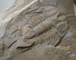
Fossilized trilobites

located in the Pioche Hills located in eastern Lincoln County, Nevada near the historic mining town of Pioche is a formation known which creates The Lower-Middle Cambrian boundary interval within the southern Great Basin and Mojave Desert region.  Here in the  long outcrop a belt occurs within a mountain chain which trends southward along the west side of the Bristol, Highland, Chief, and Burnt Springs Ranges to Lime Mountain in the Delamar Mountains. With in the shale of these ranges especially the Middle Cambrian Pioche Shale occurs which in the Pioche Hills located in eastern Lincoln County, Nevada. These areas are rich in fossilized trilobites within the prehistoric Cambrian shelf a transect would associated with depth changes across the shelf a prehistoric ocean.

Locating Fossils

The most efficient way to locate fossilized trilobites is to examine the shale formations both above and below the surface is to dig into the slabby-weathering siliceous shales, exposing fresh sedimentary strata below the surface. Fortunately, most of the shales within a few inches of the surface are severely fractured; hence, little splitting of them is necessary, since they tend to separate from the outcrops in thin sheet-like plates. Watch for the fossil compressions and impressions along the bedding planes of every shale fragment you remove from the hillside exposures. The deeper you dig, though, the more thickly bedded the opaline shales become, until at last it will become necessary to begin splitting the extremely dense, concrete-like rocks. When doing this, always remember to wear safety goggles, or at least some kind of eye protection such as sunglasses. The denser, thick-bedded opaline strata crack apart only with the greatest of applied brute force, thus increasing the likelihood that sharp fragments might launch off the matrix into your eyes. Stand slabs of shale on end, then give them a sure whack with the blunt end of a geology hammer. If you’re fortunate, the sedimentary layers will break apart along their original planes of deposition, revealing perfect carbonized leaf and seed impressions and compressions to their first light of day in approximately 16 million years.

Published in: on October 28, 2009 at 4:19 PM  Comments Off on Locating Fossilized trilobites In Nevada  
Tags: , , , , , , ,

Nampaweap Petroglyphs, AZ

This is an isolated drive take it very serious, BE PREPARED
The Nampaweap Petroglyphs are etched into black basalt rock along what is believed to be a route the Anasazi and their predecessors took to travel in and out of the Grand Canyon. In Paiute, Nampaweap means “foot canyon.”
The petroglyphs are not inside the park, but they are a short jaunt off the road on the way to Tuweep.  Peck marks are visible on many of the rocks leading researchers to believe the Indians used the method known as pecking to carve the petroglyphs.
Nampaweap Petroglyphs, AZ
Before venturing into the Monument, be sure you are well prepared to deal with the rough roads and isolated conditions.

There is a great diversity of habitat types in the Grand Canyon-Parashant National Monument, from the 2000 ft elevation hot Mohave Desert creosote bush and Joshua trees, to the Great Basin pinyon-juniper and sagebrush, to the Colorado Plateau grasslands, shrubby red rock desert, and ponderosa pine, gambel oak, and aspen communities on the 8000 ft peaks.
Containing thousands of rock art elements on hundreds of boulders along a basalt rim 1/2 mile long, Nampaweap is worth the bumpy road and the 1/2 mile walk to the site from the parking area.
Directions from St George, Utah: Take Quail Hill Road (BLM Road 1069) to Main Street Valley Road (County Road 5), drive past Mt. Trumbull to the Arkansas Ranch Road (BLM 1028), turn right and drive south about 1 mile to the signed parking area. Park and follow the trail signs to the east.
Seasonal Information:
Normally Open: Year-round .

Strawberry Point. UT


Strawberry Point. UT
Strawberry Point Drive for spectacular views of forested land and red rock formations. Strawberry Point is located just past Duck Creek Village once passing Duck Pond Strawberry Point Drive is 9 miles from the turnoff.
Strawberry Point is a mountain cliff in Iron County in the state of Utah (UT).
Strawberry Point climbs to 8,373 feet (2,552.09 meters) above sea level. Strawberry Point is located at latitude – longitude coordinates (also called lat – long coordinates or GPS coordinates) of N 37.751088 and W -112.943001.
Anyone attempting to climb Strawberry Point and reach the summit should look for detailed information on the Strawberry Point area in the topographic map (topo map) and the Summit USGS quad.
Strawberry Point. UT
Peak Type: Cliff
Latitude: 37.751088
Longitue: -112.943001
Peak Elevation: 8,373 feet (2,552.09 m)
Nearest City: Summit (3.2 miles away)

Strawberry Point Drive out to the scenic view point of Strawberry Point for spectacular views of forested land and red rock formations. A high clearance vehicle makes this a nicer drive. Duck Pond is 9 miles from the turnoff to Strawberry Point. Strawberry Point is a mountain cliff in Iron County in the state of Utah (UT). Strawberry Point climbs to 8,373 feet (2,552.09 meters) above sea level. Strawberry Point is located at latitude – longitude coordinates (also called lat – long coordinates or GPS coordinates) of N 37.751088 and W -112.943001.
Anyone attempting to climb Strawberry Point and reach the summit should look for detailed information on the Strawberry Point area in the topographic map (topo map) and the Summit USGS quad. To hike and explore the Utah outdoors near Strawberry Point, check the list of nearby trails.
Read Condition Reports | Add Condition ReportView Locator Map and Local WeatherPeak Type: CliffLatitude: 37.751088Longitue: -112.943001Peak Elevation: 8,373 feet (2,552.09 m)Nearest City: Summit (3.2 miles away)


Power Line Road Petroglyphs, NV

Power Line Road:
Take I-15 to Exit 27 (Hwy 146 – St. Rose Parkway), go 1 block east to S. Las Vegas Blvd.  Then turn right on S. Las Vegas Blvd. and go south approximately 2 miles to the power lines.  Or, if you are heading south on Las Vegas Blvd. continue on past the intersection of St. Rose Parkway for approximately 2 miles to the power lines.  If you are using mileage along with GPS coordinates, “zero your mileage” where the Power Line Road meets Las Vegas Blvd.
Turn left (east) under the power lines on the Power Line Road.
The first thing that you will come to is the Magnolia Power Sub Station.  You can go around it either to the left or right side staying on the road next to the sub station fence.  Once around the back side of the sub station you will see where the Power Line Road continues.  Follow the rusted power poles.
At approximately 3.6 miles from Las Vegas Blvd. you will come to the new dirt road crossing the Power Line Road.  Cross this road, continuing on the Power Line Road.
Stay on the Power Line Road, until you come to pole number X12084 (metal tag) – also the number 2068 is spray painted on the same pole.  About 100 feet after the pole, there will be a dirt road going to the right.  Turn right (south) and travel about .5 of a mile and you will drop into a dry wash.
Turn right in the wash.  Staying in the wash, the parking area is approximately .6 of a mile up the wash.  The parking area is as far as you can drive.  There is a sign with information and a sign in box at the parking area.  From here you walk up the wash to the petroglyph area.
The distance from the parking area to the main petroglyph site is approximately 1.1 miles.  Keep alert and you will see a few isolated petroglyphs (on your right) and a couple of nice panels (on your left) along the route to the main site.  At approximately .8 of a mile you will encounter the first of several small dry falls – this one was the location of the original parking area.  The next small rock area (dry fall) is about another .1 of a mile further and both are easily negotiated.
Continue to the last set of dry falls, which marks the beginning of the main site.  The petroglyphs start at the base of the lowest falls and you will see more as you are going up the rocks/falls.  Most people climb up the rocks on the left side of the dry falls (as you are facing up stream).  Once you reach the upper most of the dry falls, climb back down into the wash.  You are now at the main site.  There will be petroglyphs on both sides of the canyon, but most are on the right side as you are going up the wash.
Things that may be helpful:
The hike from the parking area to the main site is approximately 1.1 miles in a dry wash bottom made up of a loose sand and gravel mixture.  There is approximately a 170′ elevation gain from the parking area to the main site.
You will need to do some minor rock scrambling up the last set of dry falls just before the main site.
The main site has petroglyphs at the wash level as well as up on the hill sides.  You can go up on either hillside, sit down and look across to the other side.  A lot of petroglyphs that you did not see before will become visible.  The longer you look the more you will see.
I would highly recommend that you DO NOT take a passenger car to this site.  I would recommend a high-clearance vehicle because there are several places on the Power Line Road that are prone to wash outs.
For up-to-date information on road conditions, please call the Las Vegas BLM office at (702) 515-5000.
Image Pending

Image Pending

Power Line Road:
Take I-15 to Exit 27 (Hwy 146 – St. Rose Parkway), go 1 block east to S. Las Vegas Blvd.  Then turn right on S. Las Vegas Blvd. and go south approximately 2 miles to the power lines.  Or, if you are heading south on Las Vegas Blvd. continue on past the intersection of St. Rose Parkway for approximately 2 miles to the power lines.  If you are using mileage along with GPS coordinates, “zero your mileage” where the Power Line Road meets Las Vegas Blvd.
Turn left (east) under the power lines on the Power Line Road.
The first thing that you will come to is the Magnolia Power Sub Station.  You can go around it either to the left or right side staying on the road next to the sub station fence.  Once around the back side of the sub station you will see where the Power Line Road continues.  Follow the rusted power poles.
At approximately 3.6 miles from Las Vegas Blvd. you will come to the new dirt road crossing the Power Line Road.  Cross this road, continuing on the Power Line Road.
Stay on the Power Line Road, until you come to pole number X12084 (metal tag) – also the number 2068 is spray painted on the same pole.  About 100 feet after the pole, there will be a dirt road going to the right.  Turn right (south) and travel about .5 of a mile and you will drop into a dry wash.
Turn right in the wash.  Staying in the wash, the parking area is approximately .6 of a mile up the wash.  The parking area is as far as you can drive.  There is a sign with information and a sign in box at the parking area.  From here you walk up the wash to the petroglyph area.
The distance from the parking area to the main petroglyph site is approximately 1.1 miles.  Keep alert and you will see a few isolated petroglyphs (on your right) and a couple of nice panels (on your left) along the route to the main site.  At approximately .8 of a mile you will encounter the first of several small dry falls – this one was the location of the original parking area.  The next small rock area (dry fall) is about another .1 of a mile further and both are easily negotiated.
Continue to the last set of dry falls, which marks the beginning of the main site.  The petroglyphs start at the base of the lowest falls and you will see more as you are going up the rocks/falls.  Most people climb up the rocks on the left side of the dry falls (as you are facing up stream).  Once you reach the upper most of the dry falls, climb back down into the wash.  You are now at the main site.  There will be petroglyphs on both sides of the canyon, but most are on the right side as you are going up the wash.
Things that may be helpful:
The hike from the parking area to the main site is approximately 1.1 miles in a dry wash bottom made up of a loose sand and gravel mixture.  There is approximately a 170′ elevation gain from the parking area to the main site.
You will need to do some minor rock scrambling up the last set of dry falls just before the main site.
The main site has petroglyphs at the wash level as well as up on the hill sides.  You can go up on either hillside, sit down and look across to the other side.  A lot of petroglyphs that you did not see before will become visible.  The longer you look the more you will see.
I would highly recommend that you DO NOT take a passenger car to this site.  I would recommend a high-clearance vehicle because there are several places on the Power Line Road that are prone to wash outs.
For up-to-date information on road conditions, please call the Las Vegas BLM office at (702) 515-5000.

Coordinates for the Power Line Road:

Description Lat/Lon NAD 83/84
Las Vegas Blvd & Power Line 35d 56.285′  115d 11.151′
Magnolia Sub Station 35d 55.697′  115d 10.495

Right turn after power pole #2068

35d 55.455′  115d 07.462′
Turn right into the wash 35d 54.966′  115d 07.379′
Parking area 35d 54.541′  115d 07.459′
Last dry falls/main site 35d 53.848′  115d 07.390′

Published in: on October 15, 2009 at 6:01 PM  Comments Off on Power Line Road Petroglyphs, NV  
Tags: , , , , , , , ,

The Moon, AZ – GrandStaircase Escalante National Monument
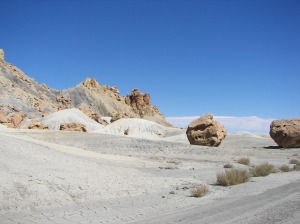
Grand Staircase-Escalante National Monument and Dinosaurs
The 1.7 million acres of the Grand Staircase-Escalante National Monument has history, literally, right at your feet. Within the boundaries of this national monument, fossil records of the earth and its inhabitants dating back more than 70 million years. These fossil records show that this arid desert has been an ocean, lake and swamp. Paleontologists have shown this through the fossils they have found. Fossil types include fish, turtles, sharks teeth, plant life and dinosaurs. Several of the dinosaurs were first discovered at Grand Staircase-Escalante National Monument. Several dinosaur tracks have also been found throughout the monument. Professional digs in the area completed as recently as 2001 have lead to some of very exciting dinosaur finds. In fact, the paleontologists that have done work in the area say that Grand Staircase-Escalante National Monument has the highest concentrations of dinosaur fossils found anywhere in the world. You can go fossil hunting and explore the history of the earth, but remember to leave what you find so that others may have the same exciting experience.
The Moon - GrandStaircase Escalante National Monument

The Moon - GrandStaircase Escalante National Monument

Grand Staircase-Escalante National Monument and Dinosaurs
The 1.7 million acres of the Grand Staircase-Escalante National Monument has history, literally, right at your feet. Within the boundaries of this national monument, fossil records of the earth and its inhabitants dating back more than 70 million years. These fossil records show that this arid desert has been an ocean, lake and swamp. Paleontologists have shown this through the fossils they have found. Fossil types include fish, turtles, sharks teeth, plant life and dinosaurs. Several of the dinosaurs were first discovered at Grand Staircase-Escalante National Monument. Several dinosaur tracks have also been found throughout the monument. Professional digs in the area completed as recently as 2001 have lead to some of very exciting dinosaur finds. In fact, the paleontologists that have done work in the area say that Grand Staircase-Escalante National Monument has the highest concentrations of dinosaur fossils found anywhere in the world.
The Moon - GrandStaircase Escalante National Monument

The Moon - GrandStaircase Escalante National Monument

You can go fossil hunting and explore the history of the earth, but remember to leave what you find so that others may have the same exciting experience.
Directions by Google can be obtained here
Published in: on October 12, 2009 at 1:20 PM  Comments Off on The Moon, AZ – GrandStaircase Escalante National Monument  
Tags: , , , , , , ,