Moab & The Four Corners

Moab & The Four Corners

Some of the areas highlighted in this book are:


House On fire Ruins


Sego Canyon Petroglyphs


Canyonlands-Needles District


Salmon Ruins


Newspaper Rock


Hovenweep National Monument


Mule Canyon Cave Tower Ruins


Sand Island Petroglyphs


Monument Valley


Moab


Cisco Ghost Town


Halfway Stage Station Ruins


Mill Creek Canyon Dinosaur Trail


Edge of Cedars State Park


Mule Canyon Roadside Ruins


Trail of The Ancients National Scenic Byway


Butler Wash & Mule Canyon Indian Ruins


Bridges National Monument


Grand Gulch Primitive Area


Four Corners Monument


Three Kiva Pueblo


Gooseneck State Park


Valley of The Gods


Coronado State Monument Kuana Ruins


Canyon of The Ancients


Horseshoe canyon


Anasazi Indian Village State Historical Monument


Ute Mountain Tribal Park


Mesa Verde

Published in: on September 16, 2013 at 5:45 PM  Comments Off on Moab & The Four Corners  
Tags: , , , , ,

Calico Mine & Ghost Town, CA

Calico Mine & Ghost Town

Calico is a ghost town located in the Mojave Desert region of Southern California. Founded in 1881 as a silver mining town, today it is a county park. It is located in unincorporated San Bernardino County off Interstate 15, 3 miles from Barstow.

Calico Mine & Ghost Town

At its height, shortly after it was founded, Calico had a population of 1,200 people and over 500 silver mines. Besides the usual assortment of bars, brothels, gambling halls and a few churches, Calico also supported a newspaper, the Calico Print. In the mid 1890s the price of silver dropped and Calico’s silver mines were no longer economically viable. With the end of borax mining in the region in 1907 the town was completely abandoned. The last original inhabitant of Calico before it was abandoned, Mrs. Lucy Bell Lane, died in the 1960s. Her house remains as the main museum in town.
In 1951, Walter Knott, founder of Knott’s Berry Farm, purchased the town and began restoring it to its original condition referencing old photographs. In the late 1950s, a western garbed man with Custer whiskers known as Calico Fred was a local fixture.  Though five of the original town buildings exist today, many others were recreated as replicas of their originals on preexisting foundations. In 1966, Knott donated the town to San Bernardino County, and Calico became a county regional park.
Today, the park operates mine tours, gunfight stunt shows, gold panning, a restaurant, the Calico & Odessa Railroad and a number of general merchandise stores. It is open daily, and requires an entrance fee. Calico is a registered California historic monument and the “official state silver rush ghost town” of California.

Beaver Dam Wilderness Pioneer Ruins, AZ

Beaver Dam Wilderness Pioneer Ruins, AZ

The Virgin River has helped to create several impressive Southwestern landscapes, starting with the great white cliffs and canyons of Utah’s Zion National Park and ending at the upper end of Lake Mead in Nevada, where it eventually meets the Colorado River. In between, it flows across the very northwest tip of Arizona for 30 miles, through two gaunt ranges of hills – the Virgin and Beaver Dam Mountains, which have similar, Grand Canyon-like scenery of eroded, stepped cliffs and terraces of metamorphosed sandstone. The Virgin Mountains are the more extensive and isolated range, running alongside the river as far as the north edge of the lake, and forming the southwest edge of the Colorado Plateau; to the west stretch the flat, arid plains of the Mojave Desert, terrain that extends for hundreds of miles across Nevada and California. The Beaver Dam Mountains are a little more accessible but just as rugged and scenic, and part is a designated wilderness area – an untamed region of Joshua trees and cacti, lizards and mountain sheep, and much colorful, weathered rock.

Beaver Dam Wilderness Pioneer Ruins

Along the Virgin River if one wishes to experience the pioneer spirit one may wish to check this out along Interstate 15 just exiting the Virgin River Gorge to the north several pioneer ruins are visible although almost un-noticeable access can be found by taking Beaver Dam Littlefield exit and following it through Beaver Dam and following old highway 91.   On the right you will see an access road stating Virgin River access the first authorized road on the right take this road and follow this map once parked you can hike the rest.

Beaver Dam Wilderness

Jensen Lime Kiln, UT

JENSEN LIME KILN

JENSEN LIME KILN – Built in 1903 by Jens L. Jensen, Richfield well known lime burner cured lim for mortar to be used in rock and brick structures. The kiln measures 20 feet high and about 20 feet in diameter, with a wall thickness of 8 feet. Over his lifetime, Jensen went blind because of the heat of the kiln. The kiln is located at the north end of Richfield (under the I-70) overpass and remains the same today as when it was operational.

JENSEN LIME KILN

Published in: on April 12, 2010 at 12:05 PM  Comments Off on Jensen Lime Kiln, UT  
Tags: , , , , , ,

San Rafael Swell, UT

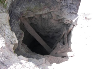
San Rafael Swell - Vertical Mine Shaft

History and Activities: Historically, the Swell was crossed by various expeditions during the exploration of the West but received virtually no permanent settlement. More recently, the area has seen sporadic mining operations – principally for uranium (most intensively around the Temple Mountain area) but also for small amounts of copper, silver, oil and gas; otherwise, ranching has been and continues to be the only major use of the land. Herds of wild horses and burros roam the plains, and bighorn sheep may sometimes be spotted in the canyons. Most of the tracks across the swell result from prospectors in the early to mid twentieth century, and these provided the only access until 1972, when the interstate was constructed, dividing the region in two.

San Rafael Swell - Vertical Mine Shaft

Various exits now allow easy entrance to the middle section and link with the old tracks, most of which are good for regular vehicles and quite well signposted. Hiking and exploring are the main reasons to visit nowadays – there are trails to mountains, historic sites, old mines and the numerous canyons – these offer experiences ranging from extended, strenuous trips like the hike through the Black Boxes of the San Rafael River to easy walks such as that down Little Wild Horse Canyon.

San Rafael Swell -  Mine Shaft

Temple Mountain: The most accessible area of the San Rafael Swell is around Temple Mountain in the southeast, beside the road to Goblin Valley State Park. Half way to the park (6 miles from UT 24), a side track branches off westwards and cuts right through the reef, the only such road along the whole eastern edge apart from interstate 70. There are many good places for free camping either side of the road, all with nice views over the reef and the San Rafael Desert – a good alternative to staying at the Goblin Valley campground, where the fees are $15 a night. The road becomes unpaved but still fine for all vehicles as it follows the canyon of South Temple Wash into the reef, where multicolored walls of Wingate sandstone rise up to 500 feet. Two sections of the cliffs on the north side have quite impressive pictograph panels, though mixed with modern graffiti. The cliffs recede on the far side of the reef to reveal an angular landscape of numerous red ridges, ravines and cliffs, with a prominent peak to the north. This is Temple Mountain – site of one of the main mining areas in the Swell, it was in use from 1910 to about 1960, extracting large amounts of uranium ore from strata of the Chinle formation. Many shafts, stone buildings, spoil heaps, rusty iron equipment and other debris remain in place, plus a large winch tower, and a walk around the mountain on old mine roads makes for an interesting hike of 2 hours or so. The rocky badlands beneath the mountain are also strewn with many pieces of petrified wood, the Chinle sandstone being the same formation as found in Arizona’s Petrified Forest National Park. The old tracks branch off the main road at the site of Temple Mountain village, a settlement that was built to service the miners and once included a gas station and general store, though little trace remains today.

San Rafael Swell

Access: The largest town nearby is Green River, 18 miles east of the reef on I-70; this is also a convenient base from which to explore the Canyonlands region to the southeast and Desolation Canyon to the north. The town has a selection of shops and cheap motels, and the John Wesley Powell River Museum – besides its interesting exhibits this has a good selection of local books and topographic maps. UT 24 and its side roads give access to the southern swell, and along here is found Goblin Valley State Park, the most visited site in this area. The northern half falls between US 191/6 and UT 10 and amongst the routes heading inwards is the unpaved Buckhorn Draw Road which leads to the single most impressive viewpoint – the Wedge Overlook from where many square miles of eroded canyons around the San Rafael River are viewable.

Bodie Ghost Town State Historic Park, CA

Bodie State Historic Park, CA Map
More than 170 buildings are protected in a state of “arrested decay” on more than 1,000 remote acres, administered by the California Department of Parks and Recreation.

Seasons / Hours
Bodie State Historic Park is open year round. It opens at 8am everyday but closing time changes seasonally (mid summer closing is at 7pm, mid-winter at 4pm).
Winter Visits
Bodie is open all year. However, because of the high elevation (8375 feet), it is accessible only by over-snow equipment during the winter months.
Many four wheel drive vehicles get stuck each year in powdery snow that is deeper than it first appears. Spring thaws bring mud, and wheeled vehicles are not advised. TOWING FACILITIES ARE NOT AVAILABLE. Snowmobiles must stay on designated roads within the park.
Winter weather is often unpredictable. Sub-zero temperatures, strong winds and white-out conditions are not uncommon. Call 760-647-6445 for current conditions
Rates & Fees
$5.00 per person – $3.00 per child (No Credit Cards) – pets must be leashed.
Facilities
There are no services, camping, lodging, food vending or stores. There is one bathroom one museum open during the summer where books on Bodie and a few other items are available for sale. Restrooms (flush toilets) are located at the parking lot.
Bodie Ghost Town State Historic Park, CA
Climate
At an elevation of 8,400 feet, it’s hot during the summer, and potentially very cold during the winter. The weather can be changeable and layered clothing is recommended.
Location – Directions
The park is northeast of Yosemite, 13 miles east of Highway 395 on Bodie Road, seven miles south of Bridgeport.
Latitude/Longitude: 38.2122 / -119.0111

From U.S. 395 seven miles south of Bridgeport, take State Route 270. Go east 10 miles to the end of the pavement and continue 3 miles on an unsurfaced road to Bodie. The last 3 miles can at times be rough. Reduced speeds are necessary. Call the park if there are any questions about road conditions.
History
The town of Bodie rose to prominence with the decline of mining along the western slope of the Sierra Nevada. Prospectors crossing the eastern slope in 1859 to search for gold, discovered what was to be the Comstock Lode at Virginia City and started a wild rush to the surrounding high desert country.
By 1879, Bodie boasted a population of about 10,000 and was second to none for wickedness, badmen, and “the worst climate out of doors.” One little girl, whose family was taking her to the remote and infamous town, wrote in her diary: “Goodbye God, I’m going to Bodie.” This phrase came to be known throughout the west.
Killings occurred with monotonous regularity here in Bodie, sometimes becoming almost daily events. The fire bell, which tolled the ages of the deceased when they were buried, rang often and long. Robberies, stage holdups and street fights provided variety, and the town’s 65 saloons offered many opportunities for relaxation after hard days of work in the mines. The Reverend F.M. Warrington saw it in 1881 as “a sea of sin, lashed by the tempests of lust and passion.”
Nearly everyone has heard about the infamous “Badman from Bodie.” Some historians say that he was a real person by the name of Tom Adams. Others say his name was Washoe Pete. It seems more likely, however, that he was a composite. Bad men, like bad whiskey and bad climate, were endemic to the area.
Whatever the case, the streets are quiet now. Bodie still has its wicked climate, but with the possible exception of an occasional ghostly visitor, its badmen are all in their graves. Only about five percent of the buildings it contained during its 1880 heyday still remain. Today, it stands just as time, fire and the elements have left it — a genuine California gold-mining ghost town. Designated a state historic park in 1962, it is now maintained in a state of “arrested decay.”
Bodie was named after Waterman S. Body (also known as William S. Bodey), who discovered gold here in 1859. The change in spelling of the town’s name has often been attributed to an illiterate sign painter, but it was really a deliberate change by the citizenry to ensure proper pronunciation.
You can see the Standard Mine and Mill on the west slope of Bodie Bluff. Because the old mill buildings and surrounding area are extremely unsafe, they are closed to the public. The mine was known as the Bunker Hill Mine when it was registered in July 1861. It passed through several hands before being sold for $67,500 to four partners, who changed the name and incorporated as the Standard Company in April 1877.
The Standard Mine yielded nearly $15 million over 25 years, and its success caused the 1878 rush to Bodie. In only a year, the population rose from about 20 to an estimated 10,000 miners, gamblers and other entrepreneurs. The Mill was destroyed by fire in 1898, but was rebuilt the following year. While the boom lasted, some 30 companies produced $400,000 in bullion per month for an overall total estimated at $90 to $100 million.
Published in: on March 12, 2010 at 2:23 PM  Comments Off on Bodie Ghost Town State Historic Park, CA  
Tags: , , , , , , ,

Valley of Fire -The Cabins, NV

The Cabins

The historic stone cabins built with native sandstone by the CCC (Civilian Conservation Corps) in the 1930’s as a shelter for passing travelers.

Park Brochure

The Cabins

The Cabins – Anasazi Petroglyph’s

The Cabins - Anasazi Petroglyph's

The petroglyph’s depicted here can be located upon the rock wall directly behind the cabins, once entering the park the directions to these formations are provided within the park informational pamphlet provided at the entrance gate.

Pioneer Park, UT

Pioneer Park, UT
Pioneer Park
Red Hills Parkway
St. George, UT
This 52 acre rustic community park is a rock climber’s paradise. From Dixie Rock, also known as the Sugarloaf, spectacular views of downtown, White Dome, Zion National Park and Arizona can be seen. This park has a large trellis pavilion with two barbecues and fire ring, several smaller picnic areas with tables, two with metal trellis pavilions, and a separate fire pit with an amphitheater. Numerous hiking trails provide access to a Boy Scout Cave, historical pioneer cabin location, slot canyons and a connection into the Red Cliffs Desert Reserve.
Pioneer Park, UT
Amenities
• BBQ • Picnic Tables • Covered Pavillion • Walking Path
• Parking • Reservable • Trail
Pioneer Park is tucked into the cliffs just north of downtown St. George, and at this position at it has a stunning panoramic view of the city. It is also a great spot to hike, bike, and picnic. The trails in the park are beautiful as they are surrounded by desert flora and are frequented by wildlife. Of special note, there are many short fences throughout the park that protect desert turtles from traffic on the roads near the park. St. George’s “Dixie” sign is also here.
The park is just off of Skyline Drive which serves as a bypass north of the city from Interstate 15 to SR-18.

Save 10% on RedRock Back Country Adventures

Save 10% @ RedRock Backcountry Adventures

GoldField, NV

GoldField, NVAlong Highway 95 in the eastern part of Esmeralda County is a town made famous by the Earp brothers, Wyatt and Virgil, following their famous gunfight at the OK Corral in Tombstone, Arizona. Wyatt was already in Goldfield and wrote Virgil, who was living in California at the time, to move to Goldfield where “money was following like wine.” Virgil arrived in Goldfield in the spring of 1904. Soon after arriving in Goldfield, he was hired as a deputy sheriff. Wyatt was working as a pit boss in Tex Rickard’s gambling casino. On July 8, 19 05, Goldfield suffered its first major fire when a stove exploded in a millinery shop. The town was saved when the wind shifted but not before two blocks of business houses burned to the ground. Three months later, Virgil contracted pneumonia and died. Wyatt left Nevada shortly after Virgil’s death and spent many years mining in the Whipple Mountains on the California side of the Colorado River. He died on January 13, 19 29 at the age of 80.

GoldField, NV

Founded in 1902, Goldfield boasted a population of 30,000 during its boom year of 1906 when it produced $11million in gold. The town probably has the longest bar in the history of mining towns. The bar, Tex Rickard’s Northern, was so long it required 80 tenders to serve its customers. By 1912, ore production had dropped to $5 million. Those who recognized the signs began to leave and Goldfield eventually became what it is today-a ghost town. A drive south on highway 95 from Tonopah will take you to Goldfield-one of the must see towns

GoldField, NV

While there step back in history and visit the Santa Fe Saloon – Santa Fe Saloon was built. One of Goldfield’s oldest continuously-operating businesses, the saloon continues to offer four motel rooms as well as being a popular oasis in the desert. Complete with its false front, western wood sidewalks and rough floor planking, inside sports an original Brunswick Bar, dominating the Santa Fe’s back wall.

 Santa Fe Saloon